
Northern California Trail Spin
Why hike it when you can bike it? That’s the premise behind the Tahoe Twirl, an adrenaline-infused bikepacking route that does not disappoint.
PHOTOGRAPHY BY JUSTIN REED OLSEN
For most backpackers, hiking the entire 170-mile Tahoe Rim Trail takes about 10 days. The loop circumnavigates the famously blue Lake Tahoe in Northern California, attracting adventurists for its pristine nature, water access, wildflowers, forests, panoramic summit views, and otherworldly lava formations.
And then there’s the Tahoe Twirl. For mountain bikers seeking the same wilderness terrain and changing views as the TRT, this path reroutes as a 187-mile bikepacking circle that can be completed in half the time. The main difference is going around and not through the federally protected Desolation and Mount Rose Wilderness areas (no mountain bikes allowed).
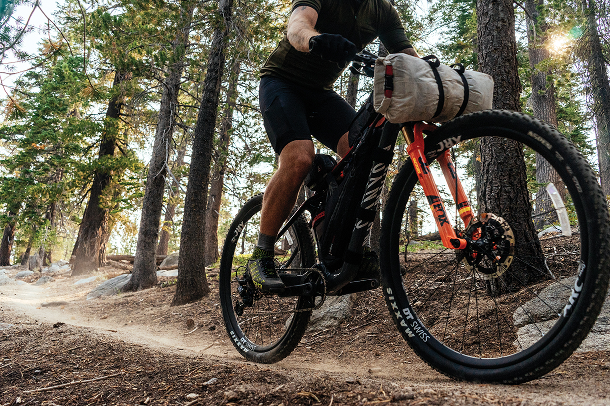
If you are unfamiliar with bikepacking, it’s what you would expect from a sport with such a name: a rugged combination of mountain biking and backpacking. The former allows for covering great distances with more ease and at higher speeds than is possible on foot. Like backpacking, bikepacking allows for multiday trips, as long as you can camp. And while riders on bicycle touring trips favor paved routes and permanent accommodations, bikepackers ride terrain that demands a lighter loadout, so streamlined packs are mounted directly to the bike, instead of comparatively heavy, bulky racks and panniers.
A lightweight road bike touring setup may have four panniers with up to 3.5 cubic feet of capacity, stuffed with potentially 50 pounds of gear or more; a typical bikepacking rig comprises a mountain bike, frame bag, seat bag, handlebar roll, and maybe a couple of small accessory bags—providing around half the total volume of the touring rig. This significant reduction allows for much greater riding agility, especially on more technical trails. Therein lies the beauty of it: the ability to tackle routes with increased capability and be rewarded for it with access to wildness and solitude not to mention greater thrills.
One significant caveat of the sport, especially on the Twirl, is that it requires a strong degree of aerobic fitness, and some previous time in the saddle. Expect to climb and descend nearly 20,000 feet over the course, with much of the elevation change occurring more than a mile above sea level; topping out just shy of 10,000 feet elevation. All of that, on a loaded-down mountain bike.
Fortunately, Lake Tahoe’s popularity translates to ample opportunities for resupplies at various tourist outposts. Instead of riding off with five days’ worth of food at the start, carry only one day’s rations. Supermarkets, grocery stores, and restaurants allow for a loadout that’s relatively light compared to what truly remote rides require.
To sweeten the deal, there is abundant access to clear rivers, lakes, and streams throughout the loop. The use of a portable water filter makes those same sources, which provide some of the country’s best-tasting tap, totally safe to drink; it’s not necessary to carry more than a few water bottles at a time.
That clean, cool resource is the direct result of snowmelt—another factor to consider. The Twirl is best traveled clockwise between late June and early October, when snow has melted off alpine passages, but before winter arrives. The route technically begins and ends in Reno, Nevada, but starting from the quaint mountain mining town of Truckee, California, is logistically easier for those driving in from coastal California. From there the route trends north through picturesque neighborhoods and bike paths before jumping onto a stretch of rolling, flowy singletrack.
Once the path crosses the highway, it transitions to a mellow, graded forest service road that leads to back-to-back stream fords. Riders must strip off shoes and carry their bikes across barefoot. If the California trail seems to transport you back in time, recall some of these same valleys were crossed on covered wagons during the 19th century. Replenish water rations in the small, clean creeks before making the climb up to the trip’s first summit.
From Henness Pass (6,916 feet), it’s all downhill, on a bone-rattling, slate-covered doubletrack to Verdi, Nevada. A bit of highway-access-road riding leads to a bike path that follows the Truckee River all the way through Reno.
Down in the valley, it’s hot, so access points along the river offer welcome respite. But there’s no need to catch dinner, as you can buy supplies in town before beginning an afternoon climb out of the desert on a doubletrack that runs through Bureau of Land Management property. Back in the forest, there are again creeks to take water from before the finishing climb up Mount Rose (the route’s highest point) to make camp near the summit.
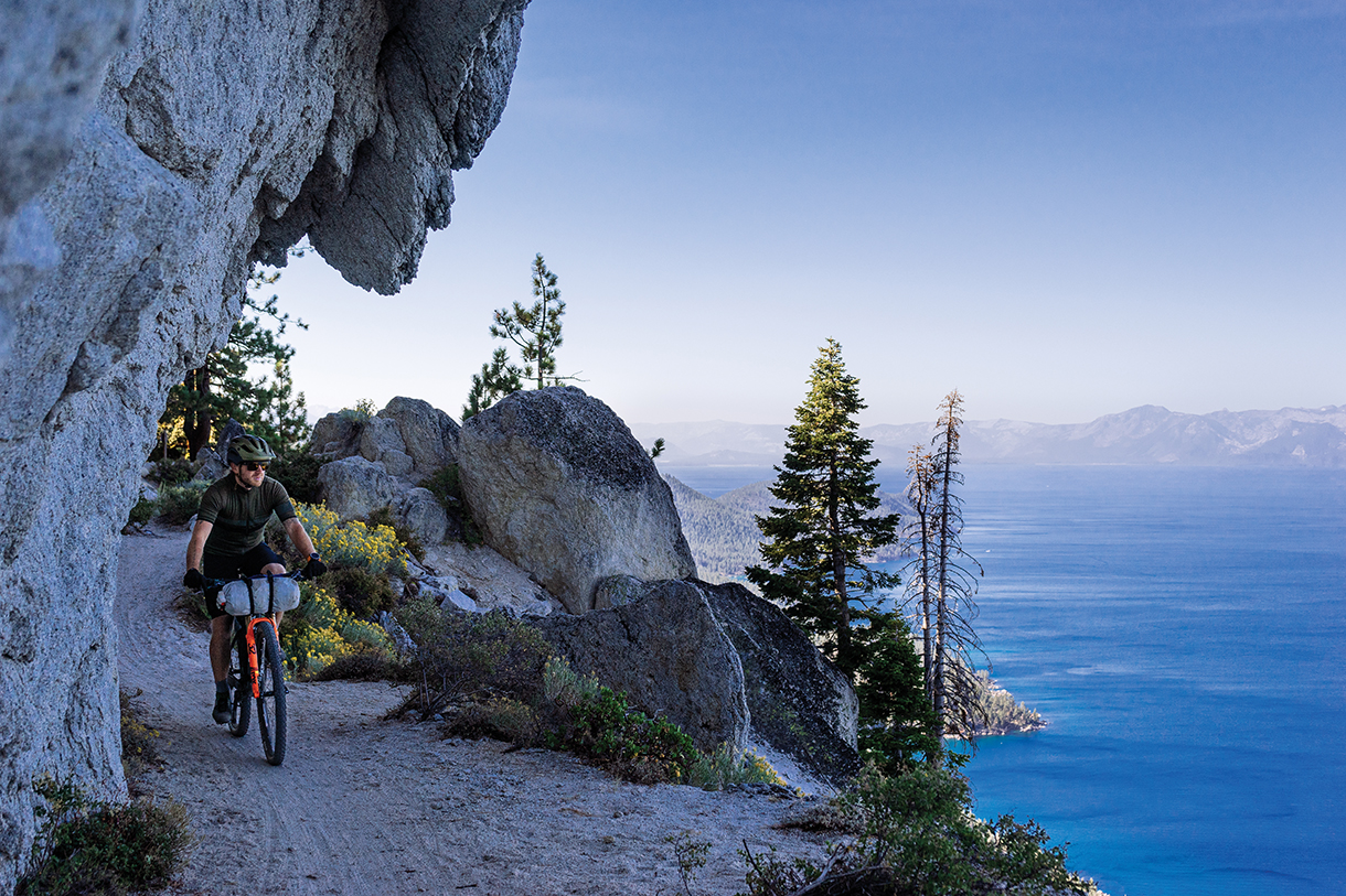
Day two begins with a blast down the highway for a mile or two back toward Tahoe before a quick pivot onto the legendary Flume Trail. This bucket-list ride is defined by its tight singletrack—cut straight out of a granite cliff band and precariously perched hundreds of feet above the lake. Consequence is high, but the risk is low, and nothing beats the thrill or the view.
Now officially on the Tahoe Rim Trail, you’ll smash singletrack and blast down the double, passing Marlette and Spooner lakes—two great options for taking a swim. Skirt the summit of Genoa Peak, taking in expansive views of Tahoe to the west, all the way to Kingsbury Grade. Resupply at the market or grab barbecue from Fox & Hound before another 8 miles and nearly 3,000 feet of gain to reach what is perhaps the trip’s most exquisite campsite at Star Lake. If you packed a portable fly rod, now’s the time to use it. The fish here bite; a supplement to dinner is all but guaranteed.
Day three makes for the most blissful part of the trip. At the intersection with the forest service road at the meadows, make sure to go right; then cross the creek to take full advantage of it. Back in the basin, a combination of singletrack, forest service roads, and bike paths lead to Highway 89—the longest, most scenic, most memorable road-riding section of the trip. Climb up past Cascade Lake, traverse around Emerald Bay, and then skirt the western shores of Tahoe on mellow bike paths. Take a swim in the lake just before Tahoe City, or in the Truckee River, which originates here.
Grab some groceries and water before the climb out of town. A slight detour to Watson Lake will make a nice place to camp; from there, it’s a short ride back down to Truckee. Mission complete.
Gear
APPAREL
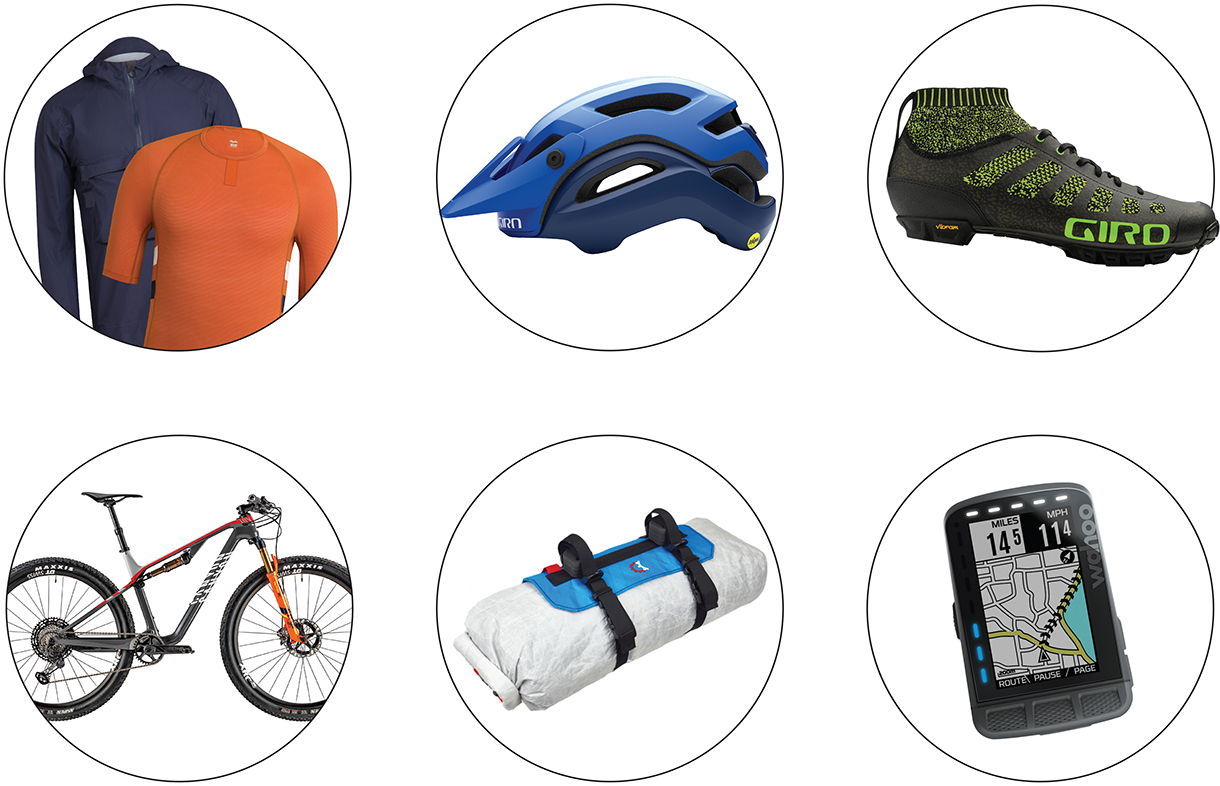
London-based Rapha (rapha.cc) designed its Brevet collection for explorers who venture off the beaten path, but still care to exude a particular degree of style and class. The Brevet Cargo Bib Shorts ($270), Base Layer (from $40), and Jersey (from $72) work with the Explore Hooded Gore-Tex Pullover (from $295) and Explore Gloves ($70) to keep you cool, dry, and dialed in no matter the riding conditions.
HELMET AND SHOES
Giro (giro.com) has you covered head and toe. The Manifest Spherical ($260) is the safest, best ventilated, most premium trail helmet available; while the VR70 Knit ($250) applies a radical new approach to off-road footwear with its Xnetic knit upper, resulting in a profoundly comfortable and breathable MTB shoe.
BICYCLE
Riding the Twirl, the contrast of technical singletrack and forest road grinds necessitate a versatile bike; the crazy light Canyon Lux CF SLX 9.0 Team ($6,000; canyon.com) features Fox 32 Stepcast Factory and FLOAT DPS Factory full suspension. The dropper post provides huge confidence when riding becomes technical; press a switch on the bars to quickly lock it out for ultimate stiffness and power transfer during steep climbs.
PACKS
After the bike, packs are at the core of bikepacking gear; Revelate Designs (revelatedesigns.com) has been at it longer than any other brand and sells incredibly versatile, dialed-in pack systems. Together the Full Suspension Frame Bag ($90), Vole Seat Bag ($160), Pronghorn handlebar system (from $145), Mag-Tank ($59), and Jerrycan ($46) provide weatherproof, innovative, easy-to-mount packing solutions—carrying and protecting your gear and providing convenient access when it’s needed the most.
COMPUTER
The Twirl is a big route, with lots of intersections and minute directional changes. The easiest way to stay on course is to sync up the GPS tracks from Ride with GPS into a Wahoo ELEMNT Roam ($380; wahoofitness.com). The ELEMNT will provide turn-by-turn directions throughout every type of path, while providing real-time metrics on everything from speed and distance traveled to slope grade and heart rate when paired with a TICKR X HR Monitor ($80).